

As of August 9, extreme drought is recorded on 59% of the country's territory, and in the deep soil layer — up to 100 cm — already on 80%. The problem has been ongoing since December 2025 and is only deepening.
Behind these numbers are very specific consequences: heat over +35 °C in the coming days, risk of fires in forests and open spaces, and later, most likely, more expensive vegetables and corn in stores. If you cultivate a plot, work outdoors, or plan to go to the mountains on the weekend — this concerns you directly.
How serious it is
According to Intersucho drought monitoring, the drought has lasted almost eight months. From December 1, 2025, to July 27, 2026, in the most critical Holíč only 43% of the long-term average precipitation fell — a deficit of 215 mm. In Hurbanovo for the same period — 46% of the norm, a deficit of 194 mm.
July rains did not save the situation because they came as local thunderstorm showers. In Hurbanovo and Rimavská Sobota less than 10 mm fell in a month, while in the Bukovské vrchy area — from 70 to 100 mm. Such distribution of precipitation does not relieve the drought.
Water is also suffering. July was recognized as dry or extremely dry in most river basins, including Ipeľ, Bodva, and Bodrog. The groundwater level is falling: 88% of monitoring sites show values below long-term averages.
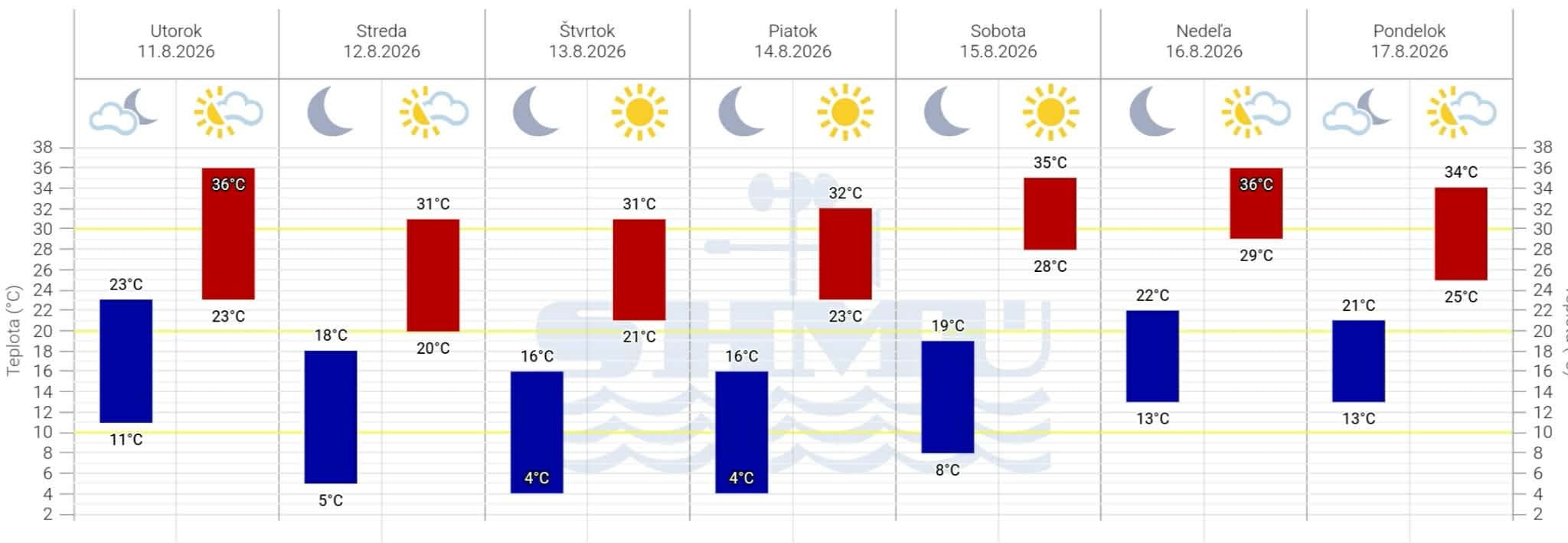
What the weather will be like in the coming days
The cold front that brought short relief yesterday has already retreated. A high-pressure area is approaching from the west. As SHMÚ explains, its stable dominance over Central Europe has blocked moist air masses all these months.
The next few days will be clear and dry, with temperatures from +24 to +31 °C. But already in the second half of the week, thermometer readings will again go above +35 °C. SHMÚ today, August 11, expanded orange heat warnings to the districts of Nové Zámky, Levice, Veľký Krtíš, Lučenec, Rimavská Sobota, Rožňava, and Košice-okolie.
Dry weather, according to the imeteo.sk forecast, will last at least until the end of the week.
When to expect rain
The break may come at the beginning of next week. Models show the arrival of a cold front with thunderstorms, precipitation, and further cooling.
But there is a nuance: after a long drought, rains are rarely uniform. If precipitation comes as intense storms, some areas may get heavy rain with strong wind and hail, while others — again nothing. The dried soil absorbs water poorly, so fast flows can cause local flooding.
What this means for you
Heat over +35 °C is dangerous for children, elderly people, and those who work outdoors — builders, couriers, warehouse workers. Drink more water, avoid the sun at midday, and do not leave children or animals in parked cars.
Those who have a garden or vegetable patch should know: farmers in the Senec region already have to constantly irrigate orchards, vineyards, and vegetables to keep them alive. The drought threatens the corn, sunflower, and soybean harvest across the country — this will affect prices in the fall.
Separately — fires. In such drought, any spark in the forest or dry grass turns into a disaster: a recent fire in the Malé Karpaty destroyed 130 hectares of forest. Avoid open flames, do not throw cigarette butts, and before going to nature on the weekend, check SHMÚ warnings.